
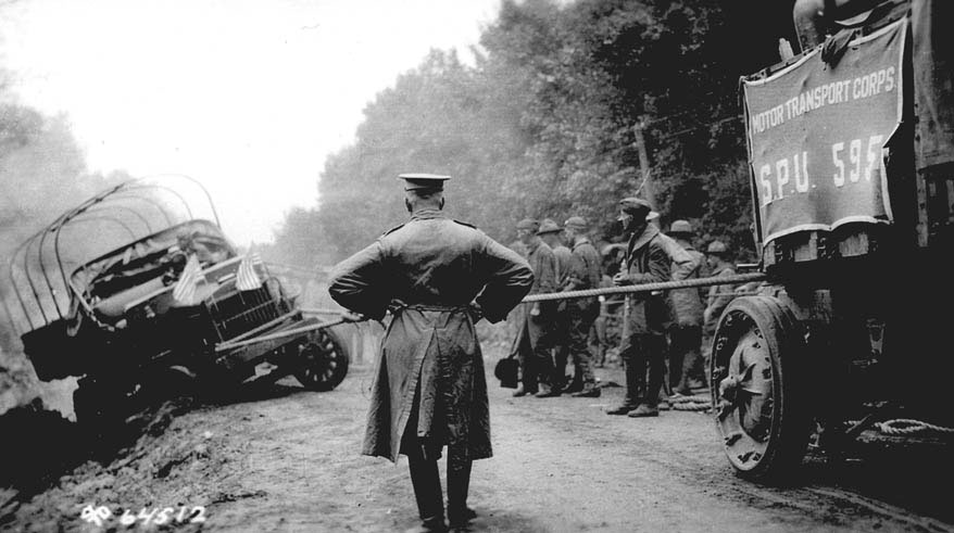
Manifold Destiny Members of an 81-vehicle Army convoy struggled to get a truck back on the road – such as it was – during a cross-country trip in the summer of 1919. EISENHOWER LIBRARY
Where, exactly, is the West and what, exactly, is it? Wrangling over these questions has gone on forever. But the answer to a corollary question — how to get there? — has changed as people left horses and steamships behind and eventually flew west. Land journeys, though, gave the region context. A crucial step came 150 years ago when two railroad lines were joined in Utah to create a transcontinental track. The West came into even sharper focus when cars could drive there.
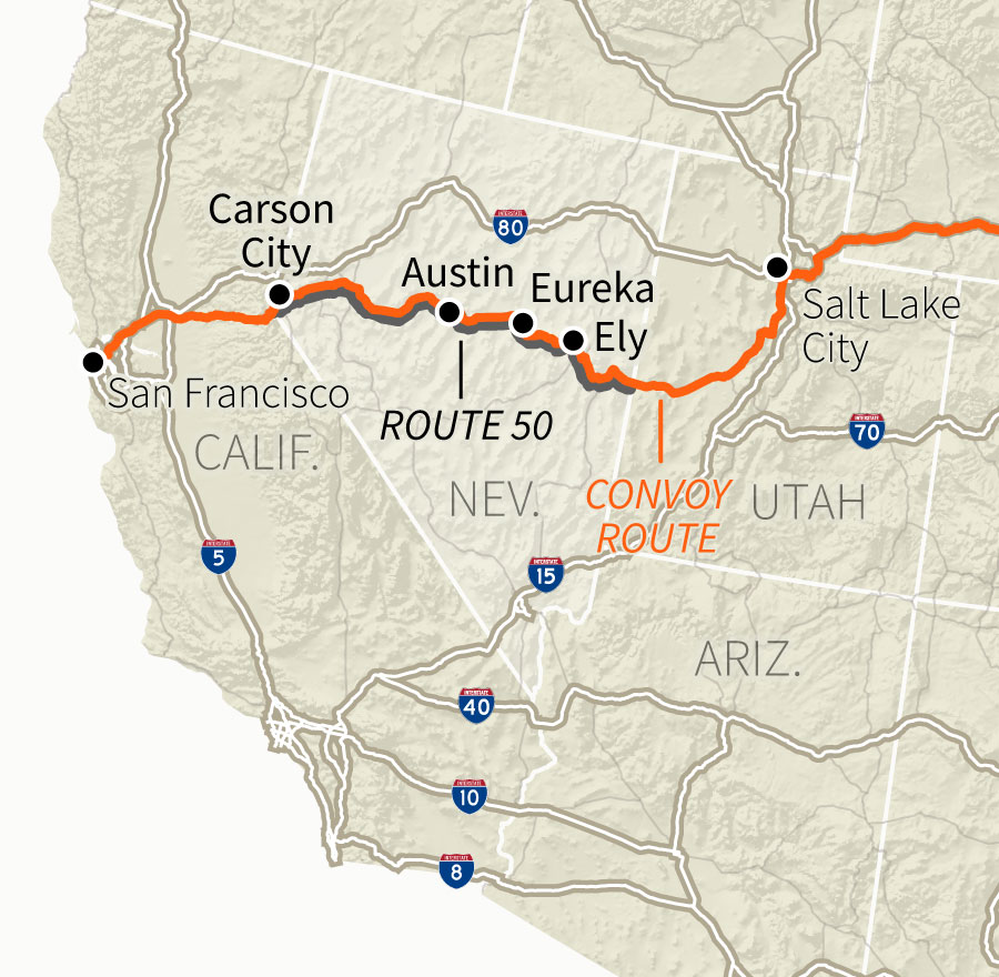
So what roads led there? After the birth of the mass-produced automobile in the early 20th century, road building had been left largely to the states, which developed roads to suit their own needs. Advocates sought to create a coast-to-coast “Lincoln Highway.” Out west they selected a course following the Overland Stage and Pony Express route through Utah and Nevada. It was the birth of Route 50, a highway at the heart of the West.
The first big test of this route’s viability came 100 years ago, when the U.S. Army, flush with victory in World War I and needing to test an overstocked inventory of trucks, mobile kitchens, mobile hospitals and repair equipment, sent an 81-vehicle convoy along the highway from Washington to San Francisco. The idea: to see how durable the equipment was and how bad the roads were.
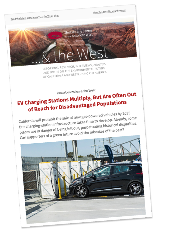
As a later review noted, the Lincoln Highway “existed largely in the imagination or on paper.” Their plan was to follow the track that became Route 50 across Nevada. The convoy spent two hot midsummer months navigating from coast to coast. It was hard going and they took heavy vehicular losses — there were 230 accidents, some because vehicles tumbled over embankments or sank in mud or quicksand. Nine vehicles were destroyed. For the convoy, the West began where roads petered out, leaving dusty, rutted paths and gullies covered by rickety bridges. As the convoy crossed, 88 bridges collapsed under the weight of the equipment. Lt. Col. Dwight Eisenhower, assigned to the convoy as an observer, wrote later that he became convinced that better highways were needed.
Engineers worked to shore up weak wooden bridges over gullies in Wyoming. EISENHOWER LIBRARY
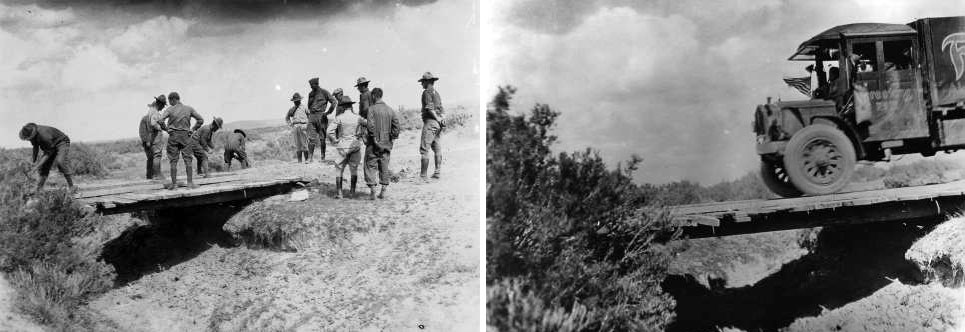
West of Grand Island, Nebraska, soldiers use a winch to pull a Class B truck out of a ditch. as Lt. Col. P. V. Kieffer surveys the scene. EISENHOWER LIBRARY VIA NATIONAL ARCHIVES.
It certainly makes sense that the convoy of 1919, whose vehicles overturned trying to navigate ravines or were damaged by primitive washboard roads, led inexorably to the interstate highway system. The Highway Trust Fund that helped pay for it was established during Eisenhower’s presidency.
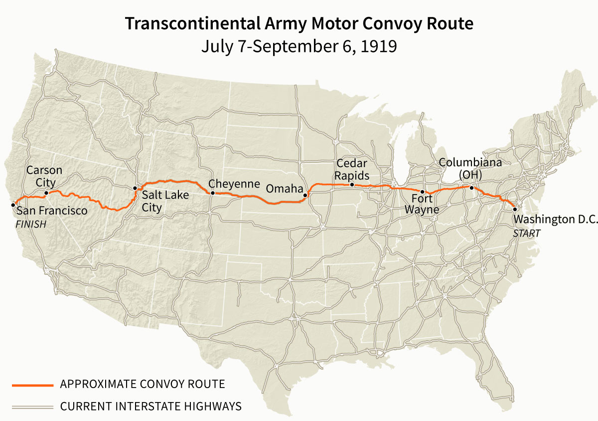
Approximate route taken in 1919. Present-day interstate highway system shown for comparison. GEOFF McGHEE/BILL LANE CENTER FOR THE AMERICAN WEST
Many Changes Have Visited Central Nevada, But Isolation Remains
But the convoy’s bumpy trip was also a distant progenitor of modern road trips. Even if smooth surfaces have covered the sand of old dirt roads, Route 50 is still a talisman of a different time, before interstates. On it are traces of old paths and the social and economic forces that created them. A 1920s fight to decide the best route across Nevada was won by proponents of a more northerly route, which Interstate 80 now follows. That highway’s appearance meant the abandonment of Route 50 as a significant cross-country route. In Nevada, it is now a road to the past.

Route 50 east of Ely, Nevada. FELICITY BARRINGER
Bill Lane Center for the American West
Traveling eastwards in 2019 over 400 miles of Nevada’s Route 50 — almost the end of the route the military convoy took westwards — the changes wrought by the last century are palpable. Smooth roads have replaced the deep ruts carved in the mid-19th century, at time of stagecoaches and the Pony Express. Endless lines of poles carrying electric wires now cross the road, which rolls by the coal-fired power plants that feed the wires and the mines that feed the plants. Sixty-two huge wind turbines of the 152-megawatt Spring Valley Wind Farm are a newer source of energy to feed into the wires that vanish in the distance.

The Spring Valley Wind Farm, about 25 miles west of the Utah border. FELICITY BARRINGER

In July 1986, Life Magazine labeled a photograph of Route 50 “The Loneliest Road in America.” Nevada officials embraced the designation with signs like this. FELICITY BARRINGER
What hasn’t changed is central Nevada’s isolation. Vast empty spaces define it, from the large valleys to the 7,000-foot peaks. In July 1986, Life Magazine published a Statue-of-Liberty-themed issue that featured a long shot of Route 50. The caption: “The Loneliest Road in America.” The Nevada tourism office embraced the designation, and put up highway signs to glorify the idea, just as it embraced the history of the Pony Express and the way stations it left in tiny towns like Austin.
Was Route 50 a lonely road in the late summer of 1919, when the military convoy came through Nevada? Here’s what then-Lt. Col. Eisenhower wrote:
From Orr’s Ranch, Utah, to Carson City, Nevada, the road is one succession of dust, dust, pits, and holes. This stretch was not improved in any way, and consisted only of a track across the desert. At many points in the road, water is twenty miles distant, and parts of the road are 90 miles to the nearest railroads.
Is it still lonely in the wired world of 2019? Well, there is little cell phone access. Towns are more than 60 miles apart. Oncoming traffic goes by in a blink — vehicles passing each other at 80 miles per hour. Such encounters happen at intervals of five minutes or more. Otherwise, all you hear is the wind blowing through acres of invasive cheatgrass; all you see is shimmering pavement headed down valleys toward distant mountains.
Small Towns Retain a Strong Whiff of the Past
A century has made little difference in the silence. Or the passion for mining, which remains, even though large, often Canadian-owned companies have replaced the prospectors of the gold-rush era and the flurry of miners who built towns that remain along Route 50.

The Eureka opera house was built in 1881, when the town’s population was around 10,000. FELICITY BARRINGER
The remnants of cultural aspirations that coincided with the mining boom of the 19th century remain. Take the Opera House in Eureka, a town whose population reached 10,000 — including many Italians and other Europeans — when it was built in 1881. There are 600 people today.
There was a different sort of culture in the tiny town of Austin, 70 miles to the west. A local coffee shop had a picture of a buxom, red-haired madam wearing nothing but some flimsy covering at a crucial juncture. More than that, wrote Adam Gorlick, a journalist who, on a brief escape from urban life, came through the town with the old Pony Express station 12 years ago. There, he heard stories of the days long before the 1919 convoy came through.
“And the hour's worth of morning entertainment at the International Cafe was worth the $2 I paid for a bowl of cut up nectarines and a cup of coffee,” Gorlick wrote his friends. “This is where I met Vic and Gail, who bought the International — an old hotel and restaurant — about a year ago. The hotel part is now mothballed, and the restaurant is kind of gross. But there's a separate saloon attached, and the bar allegedly was imported from England….”
Austin, too, had a mine-fueled population of about 10,000 at its 1880s peak; today, the number is less than 200. The town is decrepit, but the road through it is transformed from the track the convoy encountered, as described in entries from the official log:
Aug. 27: … Trailmobile Kitchen overturned on a very steep grade, was wrecked and retired from service F.W.D. #415766 burned out a connecting rod bearing when coasting down a steep grade entering Austin… Arrived Austin 2:30 p.m.
Aug. 28 : Departed Austin, 6:30 a.m. White Staff Observation Car #111506 remained behind to tighten up flanges on left rear wheel and clean out oil feed lines. … Wrecked Trailmobile Kitchen shipped back to Washington…. Two Class B trucks skidded off the road in canyons, but were rescued without damage. Spare parts truck was stuck in the sand.”
What Endures in Central Nevada

Pony Express trail marker alongside Route 50. FELICITY BARRINGER
Route 50 was never where the West began. It is where it existed and still exists, rolling through quintessential western geography — desert lands and the mountains between them. The industries along it were and are extractive. Other businesses along the route were built to carry something across long, empty distances. Letters, in the case of the Pony Express. Electricity, in the case of the power poles.
But the imperatives have changed. The military convoy’s journey made clear the need for good roads. A century later, the imperative along this stretch seems to be avoiding change. Route 50 carries with it cars, trucks, and the past. The understated “Loneliest Road” advertising makes sense. It’s hard selling dark skies with neon lights, or using noise to evoke silence.
Edited by Geoff McGhee.
Read Next in …& the West

A “Climate of Fear” Accelerates Existing Labor Shortages on California’s Farms
As field hands rethink traveling to the U.S., some farmers have been forced to watch their produce rot in the fields. Many others are cutting back acreage.
Reader Comments
Submit your own thoughts and questions by using the form at the bottom of this page. Entries will be reviewed and posted as we get them.