
The surface of Lake Oroville on Feb. 7, just as problems were appearing on Oroville Dam’s main spillway below. California Department of Water Resources
By Geoff McGhee
California avoided a major catastrophe in the past week as heavy rains compromised the 700-foot Oroville dam. As the Los Angeles Times explained, a rift gouged by water spilling over the dam was eroding a hill supporting one of the dam’s walls. Uncontrolled releases would have inundated communities in the valley below. Public safety officials called for a mass evacuation of towns downstream. Here is a day-by-day account of what happened and what state engineers and safety officials did.
Tuesday, Feb. 7: “An Unusual Flow Pattern” Discovered
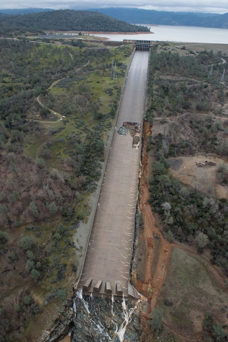
Around midday, while releasing water from Lake Oroville, dam operators notice “an unusual flow pattern and erosion” on a concrete chute designed to channel water into the Feather River.
Operators close the gates of the spillway to halt the flow and inspect the dam.
Photos taken at the time by the Department of Water Resources show a jagged gouge in the concrete bed. In a
comprehensive blog post, the earth scientist Dave Petley describes the cavity as “extraordinary erosion” and “major damage.” Petley is based at the University of Sheffield in England.
Losing the use of the chute during a period of strong rains deprives the operators of a key tool for maintaining reservoir levels and delivering irrigation water supplies as far as southern California.
Lake Oroville, which provides nearly two-thirds of the supplies delivered by the state water project, starts the day at at 80 percent of capacity, holding about 2.8 million acre-feet of water. The California Department of Water Resources (DWR) estimates that the reservoir has room for three more days of inflows, and that “there is no anticipated threat to the public.”
Ending Reservoir level: 862 feet
Wednesday, Feb. 8: Tests Further Erode Main Outlet
As Lake Oroville continues to rise from storm runoff on Wednesday afternoon, operators attempt a test flow on the damaged main spillway. DWR warns that this test is “expected to further erode the lower reach of the spillway.” After the test, Petley writes, “Unsurprisingly, the condition of the spillway has dramatically deteriorated.”
Operators continue to release water through the main spillway, but at a reduced rate of 20,000 cubic feet per second, one fifth as fast as water is entering the reservoir.
By the end of the day, the reservoir’s level is within 25 feet of the rim. The dam was designed with a notch in its rim so that when it is full, water will begin to pour down a hillside called the “emergency spillway.” This safety valve has never been used.
Toward the end of the day, operators increase the outflow rate to 65,000 cubic feet per second on the main spillway.
Reservoir level: 875 feet
Thursday, Feb. 9: Focus Turns to Never-Used Emergency Spillway
At about 6pm, inflows peak at 190,000 cubic feet per second and Lake Oroville inches closer to overflowing.
Unlike the concrete-lined main spillway, the secondary spillway’s earthen hillside is dotted with trees and shrubs; allowing water to run down it will carry large amounts of debris into the Feather River. Water flowing over this hillside is essentially uncontrolled. Workers, aided by Cal Fire crews, begin to remove trees and brush. Fish and eggs are moved from a downstream hatchery to a safer location.
The Department of Water Resources begins emergency planning in coordination with a number of state and federal agencies, from wildlife services to Cal Fire.
DWR announces, “Oroville Dam itself is sound and there is no imminent threat to the public.”
Reservoir level: 890 feet
Friday, Feb. 10: Reservoir Levels Climb
DWR’s acting director, Bill Croyle, tells reporters that “the dam itself is sound and there is no imminent threat to public.” DWR and CAL Fire crews continue clearing vegetation from below the emergency spillway.
Reservoir level: 899 feet, two feet below the maximum level
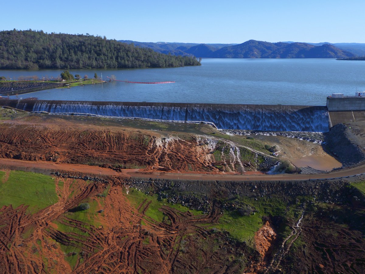
Saturday, Feb. 11: Water Overtops Emergency Spillway
Around 8 in the morning, water begins to flow over the emergency spillway for the first time in the dam’s 48-year existence; levels had come within a foot of this point during January 1997 storms.
DWR reports that the secondary spillway is carrying 5,000-10,000 cubic feet per second. This amount, combined with the releases from the main spillway, sends as much as 70,000 cfs to the Feather River.
The department’s director says that damage to the main spillway is so extensive that it will have to be rebuilt at a cost of
as much as $200 million. Aerial photos show torrents of water cascading from the lake and ricocheting off both the main spillway and the earthen face of the dam.
Reservoir level: 902.5 feet, a foot and a half above the crest of the emergency spillway weir.
Sunday, Feb. 12: Emergency Spillway Erodes, and Evacuations Are Ordered
Overnight, water releases overtake stormwater inflow and the reservoir’s level starts to drop.
In the morning, crews work to clear debris from the bottom of the main spillway so that the Edward Hyatt power station, with six generators underground near the dam, can restart and pump more water from Lake Oroville.
By mid-afternoon, DWR says that flows over the emergency spillway are declining. The dam, they say, is stabilizing.
The San Francisco Chronicle reports that “so far, the emergency spillway has worked as designed.”
Later, though, DWR discovers erosion at the top of the emergency spillway. The flow on the main spillway is doubled to 100,000 cfs to reduce strain on a concrete weir atop the emergency outlet; its failure, says DWR, could lead to uncontrolled flooding.
Around 5 P.M., evacuation orders are issued for residents of Oroville, which sits several miles downstream, and other communities as far south as Gridley, 16 miles away. Evacuation orders eventually affect more than 200,000 people in Butte, Yuba, and Sutter counties.
Reservoir level: 900 feet
Monday, Feb. 13: Urgent Repairs
On Monday morning, the dam continues to release 100,000 cfs through the main spillway, and efforts continue to restart the power plant. DWR maintains that this rate of water release is consistent for the time of year, and reservoir levels are down to 894 feet by 5pm.
DWR is using helicopters and earth-moving equipment to shore up the rim of the emergency spillway with rocks.
The evacuation order remains in effect through Wednesday, giving crews time to examine the dam and begin repairs before new storms enter the area. Beginning with
The San Jose Mercury News,
reports surface that dam managers have known for years, even decades, that the emergency spillway design was potentially flawed.
Weather forecasters predict five days of new rain in the area, beginning Thursday.
Reservoir level: 894 feet
Tuesday, Feb. 14: Evacuations Downgraded

Bill Lane Center for the American West
Levels on Lake Oroville continue to decline, as DWR acting director Bill Croyle predicts that oncoming storms will be weaker than the previous week’s and will bring less water to the area. DWR officials say that their goal is to lower Lake Oroville by 20 to 50 feet below the rim before the storms arrive on Thursday.
At the national level, the Trump administration says that it is keeping “a close eye” on developments at Oroville Dam, after Gov. Jerry Brown
on Monday calls for federal assistance for Butte, Sutter, and Yuba counties.
Reservoir level, as of 3pm: 887 feet
Read Next in …& the West

Valley Fever, a lung disease born of invasive fungal spores that are carried on clouds of swirling dust, is the best-known medical secret of the American Southwest. The parts of California and Arizona where the fungal spores flourish are once-rural places that are now population magnets, where new construction disturbs the earth and can send spores flying.


